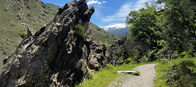
Granada, located in the heart of Andalusia, is a natural paradise for hiking enthusiasts. With unique landscapes combining majestic mountains, ancient historical routes and breathtaking canyons, this province offers options for all levels of hikers. From gentle hikes through gorges to challenging ascents to the highest peaks of the Iberian Peninsula, Granada guarantees an unforgettable experience at every step.
If you are looking for a place to connect with nature, Granada is perfect at any time of the year, but it is especially magical in autumn. During this season, the landscapes are transformed with golden and ochre tones, offering a visual spectacle that accompanies every route. The trails allow you to explore hidden valleys, cross rivers and reach viewpoints with breathtaking views.
Whether you’re looking for a quiet adventure or a more extreme challenge, Granada awaits you with a wide variety of routes that invite you to discover the natural and cultural diversity of this Andalusian jewel. Put on your hiking boots and get ready to explore this dream destination for hiking! Here are five of the province’s most emblematic hiking routes.
1. La Vereda de la Estrella
Difficulty: moderate
The Vereda de la Estrella is one of the most iconic routes in the Sierra Nevada and a classic destination for hikers in Granada. This circular route of approximately 17 kilometres offers breathtaking scenery, especially in winter, when the snow-capped peaks add a magical touch to the surroundings.
The starting point is at the confluence of the rivers Genil and San Juan, going up the slope of the river Genil until you reach the mines and the refuge of Cueva Secreta. To get there, it is necessary to go through the picturesque village of Güéjar-Sierra until you reach the Barranco San Juan Restaurant, where you can leave your car in a small car park.
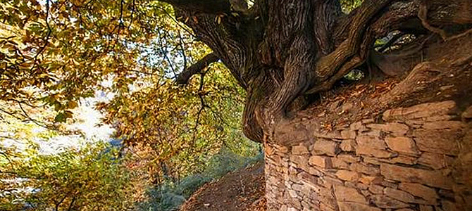
Along the route, you will find several points of interest. One of the most outstanding is the centenary chestnut tree known as “El Abuelo”. You will also enjoy spectacular views of the Alcazaba and Mulhacén mountains, the two highest peaks of the peninsula. You can also see the old mines in the area. For the more adventurous, there is an option to detour to the Cortijos del Hornillo, where you will have stunning views of Pico Veleta before returning along the path to the Casas de la Hortichuela.
2. Los Cahorros de Monachil
Difficulty: moderate
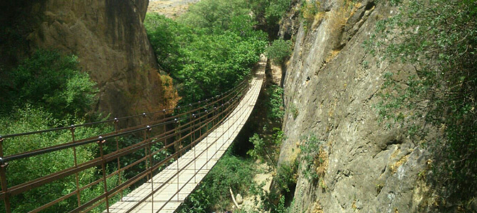
Another of the most popular routes in Granada is Los Cahorros de Monachil, an experience that combines nature and adventure. This 7-kilometre route follows the course of the Monachil River, crossing a beautiful riverside forest and several suspension bridges. The longest and most famous of these bridges, located next to a waterfall, offers a thrilling experience for hikers.
The route can be started from two points. The first, El Puntarrón, is in the upper part of Monachil, while the second, the Sendero del Río, in the lower part, is the more popular and scenic one. Along the way, you will have the opportunity to explore climbing areas and enjoy breathtaking views. The route also passes the Cueva de las Palomas, a unique rock formation wedged between two walls.
Along the route, you will find sections equipped with handrails and cables that make it easier to advance through the most complicated areas. This is an ideal route for those looking for a varied experience, where nature and adventure are intertwined in a spectacular landscape.
3. Barranco de Poqueira Route
Difficulty: moderate
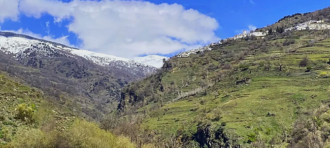
The Barranco de Poqueira Route is a circular route of about 11 kilometres that connects the picturesque Alpujarra villages of Pampaneira, Bubión and Capileira, located in the Alpujarra Granadina. Along this hike, hikers enjoy spectacular views of the Mulhacén, the highest peak of the Iberian Peninsula, while passing through traditional white villages with their characteristic flat “terraos” and flowered balconies.
The trail winds through landscapes of centuries-old chestnut groves and old Moorish irrigation channels, offering a unique combination of history and nature. The route is dotted with small bridges over the Poqueira River, as well as waterfalls and lush forests. It is a demanding but very scenic route, especially in autumn and winter, when the landscape takes on a unique atmosphere.
This route is ideal for those looking for a complete immersion in the culture and nature of the Alpujarra, while enjoying a route that alternates between sunny and shady areas, making it a perfect destination in any season.
4. Peak of Mulhacén
Difficulty: high
The ascent to the Mulhacén Peak is a challenge that every hiking enthusiast should experience. The classic route starts at La Cebadilla and continues to the Refugio de Poqueira, which allows the hike to be divided into two days. On the first day, after crossing bridges and abandoned farmhouses, you follow the course of the Barranco de Poqueira ravine to the refuge. This initial section has a gradient of 600 metres and takes about 4-5 hours of walking.
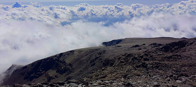
The second day begins with the ascent of Mulhacén via the Mulhacén Ravine, following its right bank to the Caldera Refuge. From here, a steep climb of 2 kilometres will take you to the summit of Mulhacén, at 3,482 metres above sea level, the highest point on the Iberian Peninsula. The views from the summit are breathtaking, with the sea to the south and the Sierra Nevada mountains all around you.
The descent follows the Loma del Mulhacén, with a cross-country option for the more adventurous. This route is not only a physical challenge, but also a unique visual experience.
5. Barranco de la Luna
Difficulty: moderate
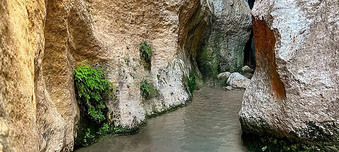
The Barranco de la Luna, located in the Lecrín Valley, is a short but spectacular route, ideal for water trekking enthusiasts. This route of about 4 kilometres runs through a 700-metre gorge carved by water, with narrow and high walls that barely allow sunlight to pass through, creating an impressive visual effect.
The walk follows the course of the river, so in several sections it will be necessary to walk in the water. This makes it a perfect route for the hot spring and summer months. Along the route, it is common to find fossils embedded in the eroded walls, which adds a historical and geological touch to the experience.
The starting point is at the Saleres cemetery, and the route continues along paths between fruit trees until it reaches the river. Although it is a short route, the charm of the surroundings will invite you to stop at several points to enjoy the scenery. The route ends when you leave the ravine by some steps carved into the rock and continue walking until you return to the starting point.